GITTA-Logo
PDF Version of this document Search Help

Lesson Navigation IconStatistics for Thematic Cartography

Unit Navigation IconBasic Statistic Rules

LO Navigation IconNominal Data

LO Navigation IconOrdinal data

LO Navigation IconNumeric data

LO Navigation IconThe Importance of Classification

LO Navigation IconData Preparation

LO Navigation IconBasic Classification Rules

LO Navigation IconSummary

Unit Navigation IconStandardisation and Classification

Unit Navigation IconStatistics for Thematic Cartography Evaluation

Unit Navigation IconSummary

Unit Navigation IconRecommended Reading

Unit Navigation IconBibliography

Unit Navigation IconMetadata


GITTA/CartouCHe news:


Go to previous page Go to next page

Ordinal data

Ordinal data is another measurement level. This data level includes both, the categorisation of data, and the ordering (ranking) of data. The ranking of data, however, does neither rely on equal category intervals, or are the chosen categories indicated by numbers, but by a qualitative ranked class description.

Ordinal data example
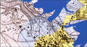
 Ordinal Data Example Ordinal Data Example (Buri et al. 1999)

Example: Hazard map of snow avalanches. The three ranks stand for hazard classes: red for high danger, blue for moderate danger, and yellow for low danger.

Top Go to previous page Go to next page