|
|
![]()
Vector Data Compression
The spatial vector data can be compressed to save computer storage space.
Point data compression
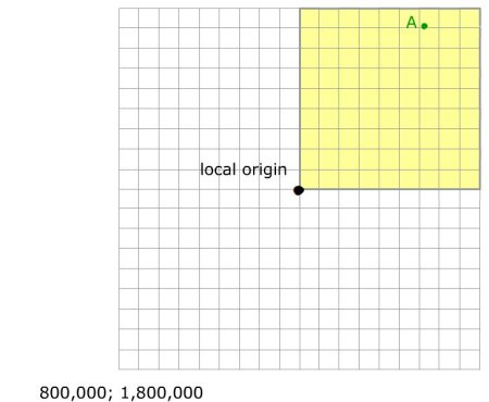
If we are considering the UTM coordinates (Universal Transverse Mercator), points are described by an easting and northing coordinate, respectively.
For example:
Point A (897'345.32; 1'898'765.98)
If we are dealing with a relatively small area, we can imagine that coordinate values are stored with considerable redundancy,
because for example the first two or three digits of all eastings and northings have the same values throughout the file.
To save storage space, it is possible to define a LOCAL ORIGIN and store all the coordinates relative to this new origin. These new coordinates will be smaller numbers than the original
ones and can be stored in a smaller amount of computer storage space.
The coordinate offsets will preserve the ABSOLUTE COORDINATES, which will be used to restore the information when we use the data.
Linear features compression
In this paragraph, we consider both linear features and polygons since a polygon is a sequence of lines.
The procedure described for the point features can also be applied to linear features where only the first point is saved
with the full coordinate information. All remaining coordinates of each line use the local origin as reference. In this case,
the local coordinates can be stored as short integer, saving 2 bytes per coordinates.
WARNING
With this compression we risk the lose of geometric precision.
Rasterising vector data and the Freeman coding
Another possibility suitable for lines is first rasterising the features onto a regular grid and afterwards proceeding with
the Freeman coding or chain coding method. With this compression method, only the coordinates of the starting point of each
line are stored.
All other subsequent points (pixels) are described by a number from 0 to 7 representing 8 possible directional positions
in respect to the previous pixel. Three bits of storage would therefore be required for each pixel of the chain code.
 Freeman coding with 8 directions
Increasing the number of directional positions from 8 to e.g. 16 (corresponding to 4 bits) or 32 (corresponding to 5 bits) it is possible to enhance the geometric precision.
CHARACTERISTICS
- Codes can be stored using integer types.
- Only boundary information is stored.
- Shape analysis is possible (perimeter, directional analysis, shape turns).
- Used in raster-to-vector conversion.
- All boundaries between regions are stored twice
|
|
|
|