|
|
![]()
Individual spatial properties of Aeral Features
Areal features such as forest land, agricultural land, park and land parcels etc. can be represented as the series of single x, y values as a closed chain in object mode or a set of contiguous grid cells with respect to row and columns in image (raster) mode. The location (position), size (area, perimeter) and shape (compactness) are the geometric properties of areal (polygon) features.
Examples
 Example of creating an areal feature in object mode
 Example of creating an areal feature in image mode
 Example of calculating area and perimeter in image mode
Calculate area and perimeter in object mode
1. Create a polygon feature in object mode based on the following table, using available GIS system at your lab. Find out the area and perimeter values calculated by the GIS system.
| Point | X(m) | Y(m) |
|---|---|---|
| 1 | 248 | 138 |
| 2 | 252 | 143 |
| 3 | 262 | 142 |
| 4 | 263 | 133 |
| 5 | 255 | 132 |
| 6 | 250 | 129 |
2. Calculate the area and perimeter of the created polygon using GIS. 3. Calculate the perimeter and area manually based on the created polygon feature.
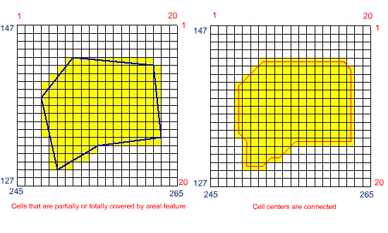
Calculate the area and perimeter in image mode
Calculate the area, perimeter of the envelope and linear perimeter in image mode at 1 meter grid cell resolution based on the following presentation.
|
|
|
|