|
|
![]()
Symbolisation
Because it is not possible to create a reduced image of the real world without devising a set of
![]() symbols that stand for real-world things, mapmaking requires symbolisation.
Symbolisation can be defined as
the graphic coding of the summarisation resulting from classification and the coding
of the essential characteristics, comparative significance, and relative positions
that result from simplification.
symbols that stand for real-world things, mapmaking requires symbolisation.
Symbolisation can be defined as
the graphic coding of the summarisation resulting from classification and the coding
of the essential characteristics, comparative significance, and relative positions
that result from simplification.
Two major classes of symbols are used:
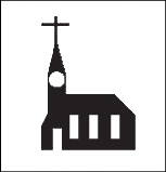
Representational Symbols:
Representational symbols are symbols whose form is derived from the appearance or nature of the feature or phenomena represented. They are designed to look like their real-world counterparts. Various forms of representational symbols exist:
| Pictorial symbol | Stylised symbol |
|---|---|
| A symbol whose form is a simplified portrayal of the feature or phenomena it represents. | A symbol whose form is derived from the salient characteristics of the feature represented. |
 |
|
For further representational symbols examples, download
here a PDF form of the Swisstopo conventional signs to the Swiss topographic maps (optional).
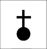
Abstract Symbols:
Abstract symbols are symbols whose form bears little or no
relationship to the form of the feature represented. For this purpose geometric symbols are
often used, e.g. circle, square, rectangle, triangle, or semi-circle. The following map of
microseismicity localisation is a typical example for abstract symbols.
 Abstract symbol example
The symbolisation process is shaped by the influence of scale: at smaller scales, it is impossible to represent geographical
features at true-to-scale likeness. Therefore, distortions are necessary when changing the scale. Symbol distortion should
be based on the logical association between the level of measurement of the map’s data and certain graphic variables, conventions
or standards, appropriateness, reader’s abilities to use the symbols, ease of construction, and similar considerations.
Discover Symbolisation with Examples.
On the following animation, you can visualize the symbolisation differences for the same original element (a castle on the
top, and a church on the bottom).
Select the slider (blue rectangle) with the mouse (continuous left click), and drag
it to the different scales to show the symbol differences.
The following will show you two map examples where symbolisation is used:
 Symbolisation example (Schweizerische Gesellschaft für Kartographie 2002)
A: Castle representation as plan view.
B: Castle representation as simplified plan view.
C: Castle representation as symbol without plan view.
D: Castle representation with equivalent symbol
size.
 Symbolisation example (Schweizerische Gesellschaft für Kartographie 2002)
A: Representation as plan view: stadium with stands, football pitch, tennis court, and parking block.
B: Regrouping of the small tennis courts.
C: Only the stadium has a sufficient size to be represented.
D: The Stadium is to small to be represented (according to the ‚A’ map is always minimal dimensions used in cartography).
|
|
|
|