|
|
![]()
Decision support for multiple objectives
If the community of St. Gittal wants to preserve peace in the village, the needs and requests of environmentalists, shepherds, and hotel directors must be taken into account. However, it is easy to see that the objectives of the various interest groups are very different.
- There are cases in which various land uses exist on the same parcel of land. By following certain rules, a hiking trail could well lead through a wolf habitat.
- However, land use demands can also exclude all other claims. A lot cannot be a wolf habitat, a pasture for sheep, and a golf course at the same time. In cases like this, different planning options need to be weighed against each other and the land has to be divided according to its suitability for different uses.
When there is more than one goal, MCE is no longer sufficient for use, instead a decision support with multiple objectives (Multi Objective Evaluation, MOE) should be implemented.
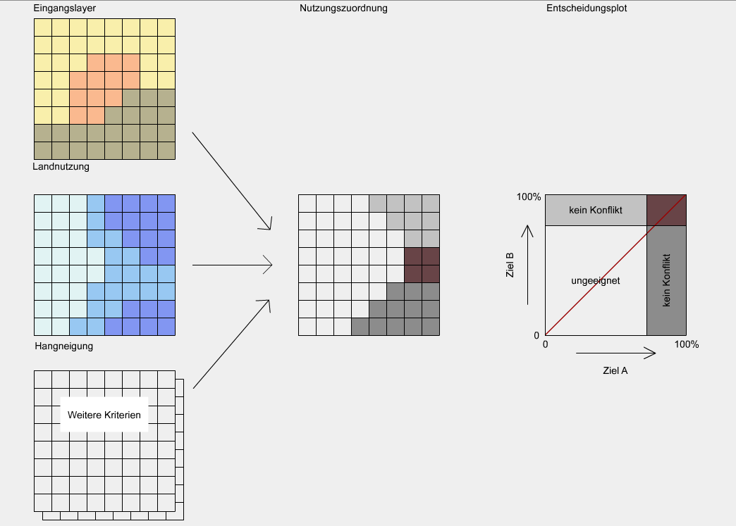
The figure shows the result of a suitability analysis for two mutually exclusive
usage rights for the municipality of St. Gittal: the two goals are called "suitable
wolf habitat" (Objective A) and "suitable for sheep grazing" (Objective B). On the
far left you will see a number of input layers for suitability analysis. Amongst others,
there are the layers for both "Land Use" (above) and "slope" (middle). The map on the
right shows the spatial allocation of the municipal area on the two uses. White is
suitable for neither (A) nor (B). Dark gray was assigned to (A) and light gray to (B).
Where light gray and dark gray overlay, there is a land use conflict (red).
In the diagram on the far right, any point in the area can be entered according to its
suitability for (A) and (B). The more a point corresponds to one criterion, the higher
is its corresponding percentage. For both (A) and for (B) a limit can be set beyond
which a point of such property is assigned to the congruent land use. All points lying
in the red rectangle in the upper right represent a usage conflict. For each one of
these points it has to be individually decided as to which land use they are assigned.
In the simplest case, a point in dispute is assigned to the land use it is better
suited: if the point lies above the red line in the diagram, it will be land use (B),
otherwise land use (A).
|
|
|
|