|
|
Production and Revision of Topographic Maps.
Production of Topographic Maps.
Years ago, topographic maps were compiled and sketched by hand. Nowadays, topographic maps are to a large extent compiled in the office with the help of a complex process based on photogrammetry. However, producing an accurate topographic map is still a long and complex process. It can take up to 3-4 years from the identification of a mapping requirement to the efficient printing of the map.
Revision of Topographic Maps.
Currently, landscapes can change quickly, especially in terms of buildings and roads. Because topographic maps are the basis for every thematic map, the official institutions avoid long time intervals between each topographic map revision. Most of the topographic maps revisions are carried out with the help of new measurements made in the field, or with recent aerial photography. In this case, topographic maps are sometimes called photorevised maps.
Remarks: Some U.S. topographic maps include the new features in purple, they can represent newly urbanised areas, new roads, and even new lakes.
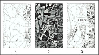
Revision of Topographic Map Example.
In Switzerland, the revision of the national topographic maps is done
approximately every six years by the Federal Office of Topography
(Swisstopo).
The example below shows a revision of a topographic map
1:25.000 of Blerick county (Great Britain).
 Revision of Topographic Map Example (Anson et al. 1984) Revision of Topographic Map Example (Anson et al. 1984) |
|
