|
|
![]()
Raster Data Structure
Raster data model
A raster is an array of cells, where each cell has a value representing a specific portion of an object or a feature.
A point may be represented by a single cell, a line by a sequence of neighbouring cells and a polygon by a collection of contiguous cells.
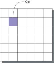
All cells in a raster must be the same size, determining the resolution. The cells can be any size, but they should be small enough to accomplish the most detailed analysis. A cell can represent a square kilometer, a square meter, or even a square centimeter.
Cells are arranged in rows and columns, an arrangement that produces a Cartesian matrix. The rows of the matrix are parallel to the x-axis of the Cartesian plane, and the columns to the y-axis. Each cell has a unique row and column address.

Resolution and storage size
Resolution can affect the data storage size. Storage requirements increase by the square of the image dimensions.
 800 x 545 pixels 325KB 800 x 545 pixels 325KB |
 |
 Zoom in by 5 Zoom in by 5 |
| 400 x 272 pixels 91KB |
|
 Zoom in by 5 Zoom in by 5 |
| 200 x 136 pixels 26KB |
|
 Zoom in by 5 Zoom in by 5 |
|
|
|
|