|
|
Task
Background and problem description
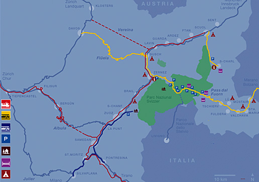
With an area of 172 km2, the Swiss National Park (SNP) is the largest wildlife protection area in Switzerland. The World Conservation Union (IUCN) classifies the park as a category I (highest protection class) reserve. The SNP is located in eastern Switzerland in the Canton Graubünden's Engadin and Münstertal valleys.
 Location of the Swiss National Park (SNP) (Schweizerischer Nationalpark)
The Swiss National Park is renowned for its alpine species richness and untouched landscape and attracts approximately 150,000 visitors per year. The park administration would like to install new, visually appealing information boards for the visitors. These information boards should show potential habitats for different animal species and give background information about the animals. To provide a range of displays to choose from, your task is to:
- spatially and quantitatively capture the potential habitats of two species of your choice using a Geographic Information System (GIS)
- prepare your results as thematic maps for the information boards
- present your approach and results at an interim and a closing event.
Data set
1. GIS data
The following GIS-data have been made available to the GITTA consortium by the Swiss National Park. Interested none-GITTA partners please contact the GITTA coordinator (coordinator@gitta.info).
| DEM | Raster | Spatial resolution: 10 x 10 m Compiled by the SNP's GIS workgroup |
| Water network | Coverage | Geostat data |
| Road network | Coverage | Main streets Compiled by the SNP's GIS workgroup |
| Hiking trails | Coverage | Mapped by the SNP's GIS workgroup |
| Park huts | Coverage | Mapped by the SNP's GIS workgroup |
| Park boundary | Coverage | Mapped by the SNP's GIS workgroup |
| Geology | Coverage | Mapped by the SNP's GIS workgroup |
| Vegetation | Coverage, dbf-Datei | Mapped by the SNP's GIS workgroup, based on (1995) |
2. Information on habitats
Informations on potential habitat requirements is available for
the following species: Rock Ptarmigan, Capercaillie, Black Grouse, Hazel Grouse, chamois,
marmot, mountain hare.
Download: Habitats.zip
3. Additional information and literature
See list of references (bibliography).
