What is GIS?
Introduction
Living in what we call ‘the age of information’ or even the ‘information society’, the availability of global networks, large data storage capacities, high resolution sensors and fast information transmission results in vast amounts of data and information that needs to be acquired, stored, organised and structured, filtered and transmitted. ‘Information systems’ are becoming increasingly important not only to manage data, but also for the interpretation of data and thus the extraction of information.
In information systems, the term data is used for unprocessed, uninterpreted data. By interpreting data, meaningful information can be extracted. However, different - even contradicting - information can often be extracted from one data source, depending on factors like perspective, interest, additional data sources or even culture.
Thus, an information system is a tool that should be able to store, transform, query, and finally present data in various ways. It is usually capable of integrating and combining data from different sources. By analyzing and interpreting this data, the data is transformed into useful information by a user. Information systems usually run on a specific computer system or over a network and require a whole suite of software packages and hardware devices.
What makes an information system a geographic information system?
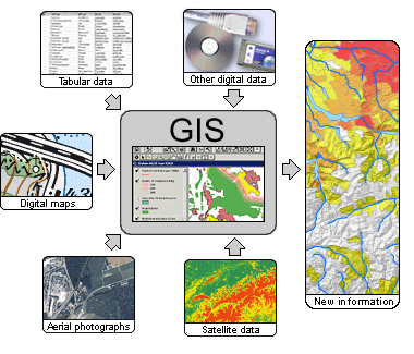
A major part of human
activity and decision-making has a direct or indirect relation to space – a lot of data can more or less be linked to a
location on earth (geographically referenced). In a GIS we can combine geographic data (or shortly called ![]() geodata)
with other types of information: this is what makes an information system a GIS, and constitutes as the basis for all its
functionality.
The aim of this lesson is to give a short introduction to GIS. The focus is on the general use, on the data and on the
display of information.
In lesson 2, different aspects of software and hardware are discussed.
geodata)
with other types of information: this is what makes an information system a GIS, and constitutes as the basis for all its
functionality.
The aim of this lesson is to give a short introduction to GIS. The focus is on the general use, on the data and on the
display of information.
In lesson 2, different aspects of software and hardware are discussed.
Learning Objectives
- You know what a Geographic Information System (GIS) is.
- You understand why there is no clear definition and the ambiguity in the usage of the term GIS.
- You know the fields of application for GIS and its limitations.
- You understand the difference between spatial and attribute data and know what topology is all about.
|
|
|
|