|
|
![]()
A general introduction to GIS
The definition of GIS
Geographic information systems are used for many different tasks and in many different fields of application. As such, a GIS often forms an interface between a variety of disciplines such as geography, information science, mathematics, surveying, or environmental science. Consequently, many different definitions about what a GIS exactly is exist and there are even lively discussions about what disciplines form the field of geographic information science. Even though the term GIS is used differently, depending on the context, some general concepts can be formulated.
Two meanings of the word GIS
There are two distinct meanings of how people use the word GIS, as shown in the two illustrations below:
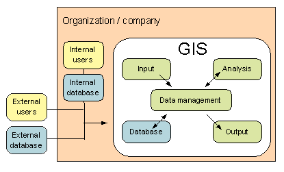 |
A GIS is a computer system, including hardware, data, software and an application to analyze and solve a space related task
(involving |
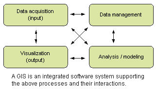 |
A GIS is a type of software, either sold by a software producer or developed by a group of volunteers and distributed as |
In this module, we will focus on the first definition, but use both meanings depending on the context. We will define a GIS as a computer system including hardware, data, software, and an application designed to acquire, manage, analyze and present geographic information in many ways.
|
|
|
|